Trail On foot Le Cannet - FARANDOLLE:ETAPE 3,LE CANNET PEGOMAS. - Photo

FARANDOLLE:ETAPE 3,LE CANNET PEGOMAS.

© OpenStreetMap contributors
Length
Length
25 km
Max alt
Max alt
255 m
Uphill gradient
Uphill gradient
540 m
Km-Effort
Km-Effort  
32 km
Min alt
Min alt
16 m
Downhill gradient
Downhill gradient
614 m
Boucle
Boucle
No
Creation date :
2020-03-27 11:55:54.26
Updated on :
2020-03-27 12:01:31.429

(0 Reviews)

On foot
On foot
--
Difficulty : Medium

Scan this QR Code to open this trail in the SityTrail application

FREE GPS app for hiking

Logo SityTrail SityTrail

IGN / Geographical institutes

Download SityTrail from the App Store Download SityTrail from Google Play

Logo SityTrail SityTrail World

The world is yours!

Download SityTrail from the App Store Download SityTrail from Google Play Download SityTrail on Huawei AppGallery

About

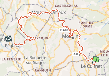
Trail On foot of 25 km to be discovered at Provence-Alpes-Côte d'Azur, Maritime Alps, Le Cannet. This trail is proposed by mjfscacrando.

Description

Au départ du Cannet on suit une partie du canal de la Siagne,passage par Mougins, Mouans- Sartoux la Roquette sur Siagne.

Elevation profile

Positioning

Country:
France
Region :
Provence-Alpes-Côte d'Azur
Department/Province :
Maritime Alps
Municipality :
Le Cannet
Location:
Unknown
Start:(UTM)
340093 ; 4826718 (32T) N.

Trails nearby

Trail Cycle Cannes - st michel to funicular - Photo
Cycle
norman0000

Cycle

Very easy
(1)
Cannes, Provence-Alpes-Côte d'Azur, Maritime Alps, France
5.3 km | 7.3 km-effort
33min
Yes
Trail On foot Valbonne - Circuit de l'Aqueduc - Photo
On foot
GUIDE+

On foot

Easy
Valbonne, Provence-Alpes-Côte d'Azur, Maritime Alps, France
6.3 km | 8 km-effort
1h 49min
Yes
Trail Mountain bike Valbonne - Valmasques pistes carton, Devens, des Moulins... - Photo
Mountain bike
GrouGary

Mountain bike

Easy
(2)
Valbonne, Provence-Alpes-Côte d'Azur, Maritime Alps, France
12.4 km | 15.3 km-effort
1h 53min
Yes
Trail Walking Le Cannet - Sur les pas de Bonnard, Le Cannet - Photo
Walking
GrouGary

Walking

Very easy
(1)
Le Cannet, Provence-Alpes-Côte d'Azur, Maritime Alps, France
4.8 km | 6.3 km-effort
1h 44min
Yes
Trail sport Mougins - Le long du canal de la Siagne (une partie) - Photo
sport
jwo47

sport

Very easy
Mougins, Provence-Alpes-Côte d'Azur, Maritime Alps, France
6.6 km | 7.9 km-effort
Unknown
Yes
Trail Mountain bike La Roquette-sur-Siagne - La Roquette-sur-Siagne - Col Notre Dame (326m) - Photo
Mountain bike
fagakra

Mountain bike

Difficult
(1)
La Roquette-sur-Siagne, Provence-Alpes-Côte d'Azur, Maritime Alps, France
37 km | 0 m-effort
2h 28min
Yes
Trail Walking Vallauris - Golfe-Juan Antibes gare à gare - Photo
Walking
pjjrevrard

Walking

Easy
(1)
Vallauris, Provence-Alpes-Côte d'Azur, Maritime Alps, France
10.2 km | 12.2 km-effort
2h 32min
No
Trail Walking Vallauris - VALLAURIS . CITE ANTIQUE DE LA CORDULA O - Photo
Walking
RobinMicheline

Walking

Medium
Vallauris, Provence-Alpes-Côte d'Azur, Maritime Alps, France
5.9 km | 7.7 km-effort
1h 50min
Yes
Trail Walking Mougins - Circuit de Fugureit - Photo
Walking
jwo47

Walking

Easy
Mougins, Provence-Alpes-Côte d'Azur, Maritime Alps, France
4.5 km | 5.9 km-effort
1h 21min
Yes


Close
My subscriptions